|
|
Geographic information is an essential reference for many areas of primary interest of the public administration.
For Regions: for the programming and planning.
For the Governatorate: for the coordination of land use plans, aimed indication of the general layout of the territory: land use, infrastructure locations, lines of action for the consolidation of the soil, the definition of the areas to be allocated to the park or reserve natural.
For the Municipalities: to the zoning general, recovery, production plants, traffic for the popular and affordable housing, to land management: the public works concessions, network services and those detailed. Without proper support, the complexity of spatial data makes it difficult to manage multiple operational levels.
|
|
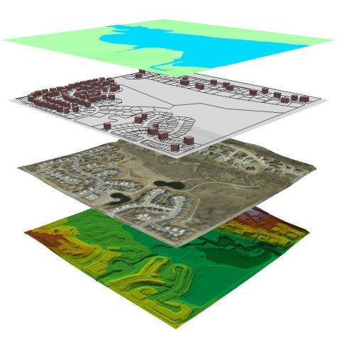
GIS systems provide valuable support to manage the complexity of spatial data; allow to have a precise and comprehensive view of the various components of the territory and to anticipate the changes and transformations; ensure that there is consistent, coherent and constantly updated, improving the management costs.
GIS systems provide a means for indispensaile:
For analysis of geographic
Design interventions in the territory
Envisage scenarios consistent with the changes that actually undergoes
Simulate the effects of natural disasters (floods, fires)
Simulating human intervention (such as planning actions)
Monitor the territory
Support decision-making processes
Improve the management of its resources
The WebGIS technology now makes accessible information to citizens on environmental, urban planning, map-based navigation offend them.
The major advantages are to give the opportunity to any user connected to the Internet that has at its disposal a browser (regardless of the operating system and the power of the PC, from the installation and place) to gain access to the maps, this opens the significant applications in the field that until recently were only accessible by users with special graphics workstations equipped with special software.
The Risviel acts as a consultant for data analysis and for setting up the system according to the purposes to be achieved, in order to make the data accessible to non-experts with the technology WebGis.
This allows you to view the various themes or to make queries with a simple graphic and alphanumeric browser.
The project is carried out alongside figures of high competence in the field of data management, mapping, and advanced technologies for the realization of applications designed query and manipulation of geographic databases via the Web.
|
|
|
ANALYSIS AND ENVIRONMENT
Environmental protection, environmental impact studies, localization of areas, locations of use, management of green spaces, definition of areas at risk, in the collection, analysis of data on pollution.
ANALYSIS RISK MANAGEMENT
Definition of the risks of fires, earthquakes, landslides, avalanches, floods, erosion and instability.
REGISTER
Managing urban and regional plans, georeferencing with cartography.
DEMOGRAPHICS
Demographic trends, employment trends, urban sprawl and residential.
MANAGEMENT NETWORK
Functions necessary for the management of water, electric, gas: cartography, technical maintenance scheduling, simulation of new circuits, fast localization of faults and oganizzazione of remedial services.
AGRICULTURE
Agro meteorology, agronomy
|